Two questions homeowners ask first
Which NC soil zone is my property in?
If you are west of I-95 and east of the mountains, you are almost certainly in the Piedmont -- NC's most common zone, with low-permeability red clay. Everything east of roughly I-95 is the Coastal Plain. The counties west of the I-77/I-40 corridor are WNC mountain territory. Zone determines drainage methodology. Start here before reading anything else.
Why does my soil zone change what drainage method I need?
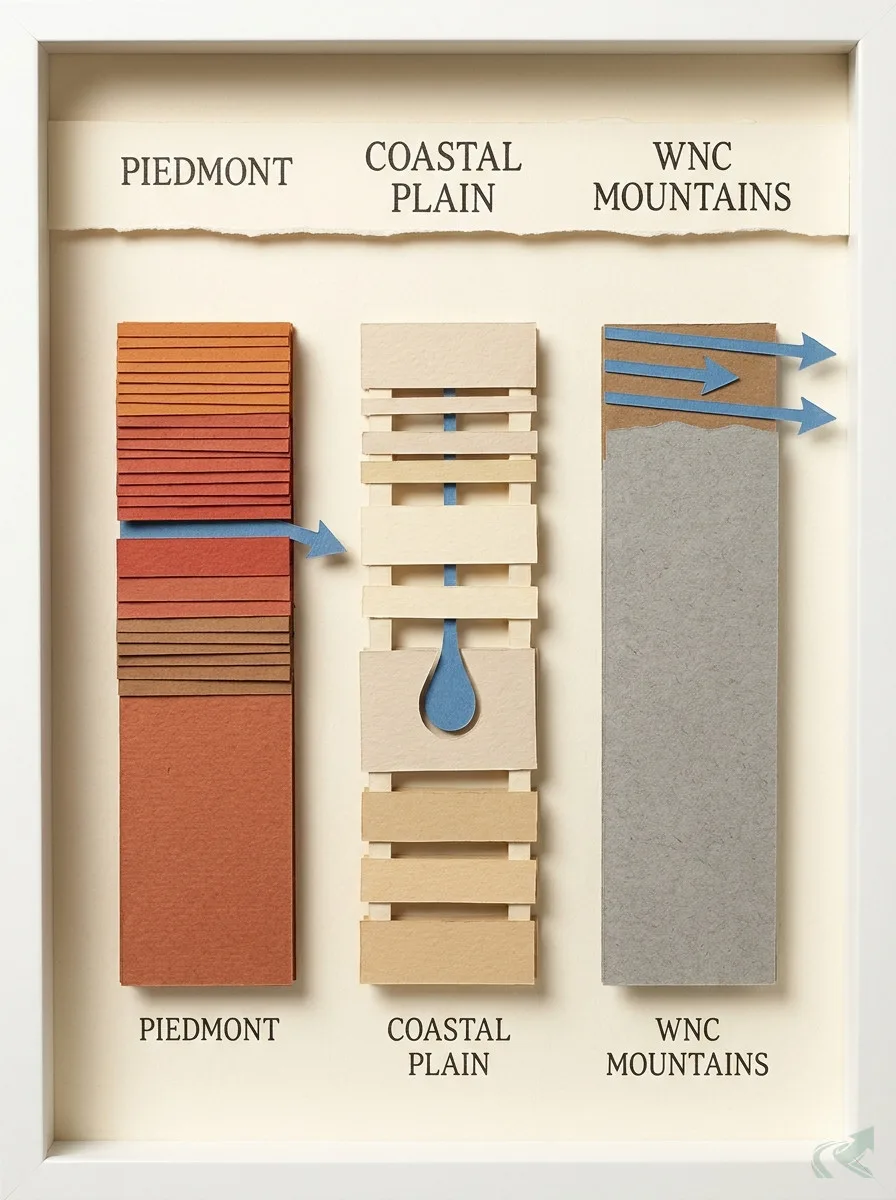
Piedmont clay does not drain vertically -- water moves sideways. Coastal Plain sand drains fast but sits on a high water table in flat terrain. WNC mountain soil is so shallow over bedrock that there is nowhere for a French drain to go. A method that works in one zone will underperform or fail completely in another, even within North Carolina.
A homeowner near Raleigh hires a contractor based on a YouTube tutorial filmed in Myrtle Beach. The contractor installs a standard French drain per the video. Two seasons later, water is sitting in the yard again.
The problem is not the contractor. The problem is the methodology. Coastal Plain sandy drainage methods do not transfer to Piedmont clay, even within North Carolina.
North Carolina spans three soil environments that behave like different states. The right approach in each zone is different enough that picking a drainage contractor without knowing your zone is guesswork. This page routes you to the right zone — and to the contractors who work in it.
Why Soil Zone Comes Before Methodology
Drainage methodology — how to route a French drain, where to set an outlet, whether to use pipe fabric — is determined by soil type. No methodology decision is correct in the abstract.
It is not that NC contractors are disagreeing with YouTube. It is that the YouTube video was filmed somewhere else. The installer is doing exactly what works at home. The soil under your yard is different, and the water does not know what the video said.
Every methodology question — depth, outlet location, pipe type, fabric yes or no — has a soil-zone-specific answer. Until you know which of NC’s three soil environments your property sits in, you cannot evaluate any contractor’s approach against anything reliable.
For a full treatment of how North Carolina differs from the national default, see why NC French drain methodology differs from other states.
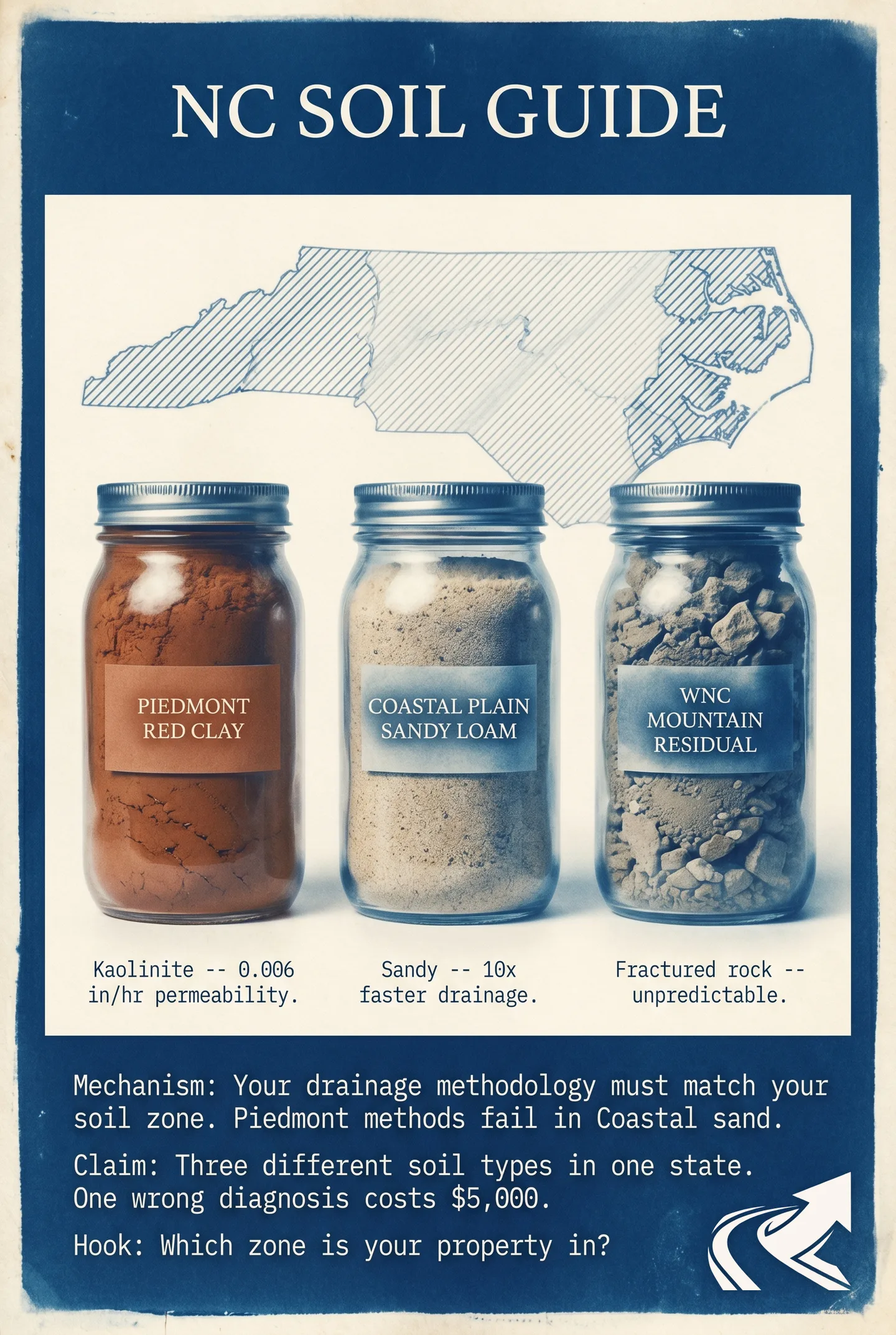
NC’s Three Soil Zones: A One-Page Map
North Carolina has three distinct soil environments: the Piedmont (red clay, low permeability, most of the state’s population), the Coastal Plain (sandy, higher permeability, east of roughly I-95), and the WNC Mountains (shallow soil over rock, surface runoff dominance).
These are physiographic approximations — not regulatory lines. Your property may sit near a boundary zone where characteristics blend. The USDA Web Soil Survey (websoilsurvey.nrcs.usda.gov) gives the exact soil series for your specific parcel.
The rough geographic boundaries:
- Piedmont: Between the fall line (roughly I-95) and the mountain foothills (roughly I-77/I-40 corridor). Contains Raleigh, Durham, Chapel Hill, Greensboro, Winston-Salem, Charlotte.
- Coastal Plain: East of approximately I-95. Contains Wilmington, Fayetteville, Goldsboro, Greenville, the Outer Banks counties.
- WNC Mountains: West of the I-77/I-40 corridor approximately. Contains Asheville, Boone, Hendersonville, Waynesville.
NC soil zones -- drainage summary. Verified May 2026 against USDA NRCS soil geography data.
| Zone | Geography | Soil Type | Permeability | Key Drainage Issue | Deep-Dive |
|---|---|---|---|---|---|
| NC Piedmont | West of I-95, east of mountains | Red kaolinite clay (Cecil, Appling series) | Low | Lateral flow -- no vertical percolation | [Piedmont red clay](/resources/piedmont-red-clay/) |
| NC Coastal Plain | East of roughly I-95 | Sandy (Lakeland, Wagram series) | High | Flat terrain + high water table in low areas | [Coastal Plain soils](/resources/coastal-plain/) |
| WNC Mountains | West of I-77/I-40 corridor | Shallow over rock (Ashe, Edneyville series) | Variable -- surface-dominated | Surface runoff -- no percolation depth | [WNC mountain soils](/resources/wnc-mountain/) |
NC Piedmont
- Geography
- West of I-95, east of mountains
- Soil Type
- Red kaolinite clay (Cecil, Appling series)
- Permeability
- Low
- Key Drainage Issue
- Lateral flow -- no vertical percolation
- Deep-Dive
- [Piedmont red clay](/resources/piedmont-red-clay/)
NC Coastal Plain
- Geography
- East of roughly I-95
- Soil Type
- Sandy (Lakeland, Wagram series)
- Permeability
- High
- Key Drainage Issue
- Flat terrain + high water table in low areas
- Deep-Dive
- [Coastal Plain soils](/resources/coastal-plain/)
WNC Mountains
- Geography
- West of I-77/I-40 corridor
- Soil Type
- Shallow over rock (Ashe, Edneyville series)
- Permeability
- Variable -- surface-dominated
- Key Drainage Issue
- Surface runoff -- no percolation depth
- Deep-Dive
- [WNC mountain soils](/resources/wnc-mountain/)
The Piedmont Zone: Red Clay and What It Means
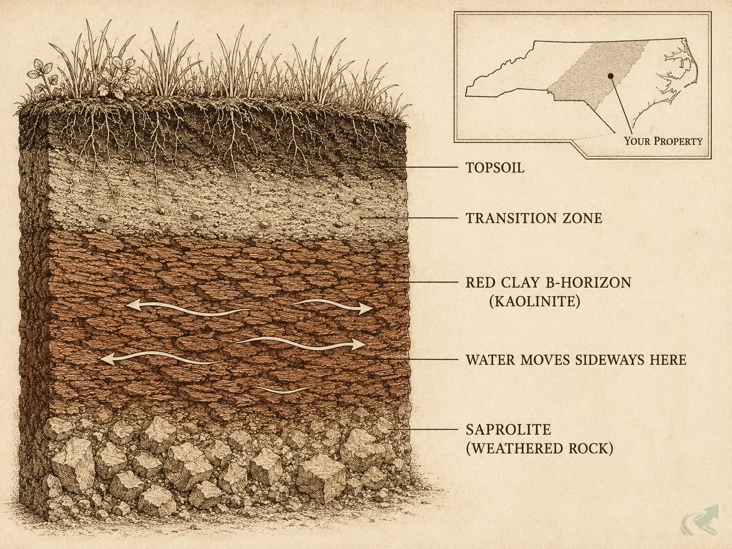
The NC Piedmont — home to Raleigh, Durham, Charlotte, Greensboro, and Winston-Salem — sits on kaolinite-dominant red clay that has very low permeability and produces lateral water flow rather than vertical percolation.
The dominant soil series in Piedmont metro counties is the Cecil series, a deep red-clay soil named for Cecil County, Maryland, where it was first classified. The Appling series is the other common Piedmont type — similar kaolinite structure, slightly different drainage behavior. Both are visually distinctive: the deep brick-red B-horizon layer appears when you dig about 6-12 inches.
Kaolinite (a clay mineral that gives Piedmont clay its flat plate-like structure) is why water does not drain downward through this soil. The plates stack tight. Hydraulic conductivity — the rate water moves through soil — is very low in the Cecil series B-horizon. Water finds the path of least resistance, which is sideways, not down.
This is not a defect you can fix with more gravel. It is a structural characteristic of the soil. Every drainage design in Piedmont clay starts from lateral flow interception, not percolation.
The full breakdown of Piedmont clay characteristics, common failure patterns, and NC-specific French drain design is at NC Piedmont red clay soil properties.
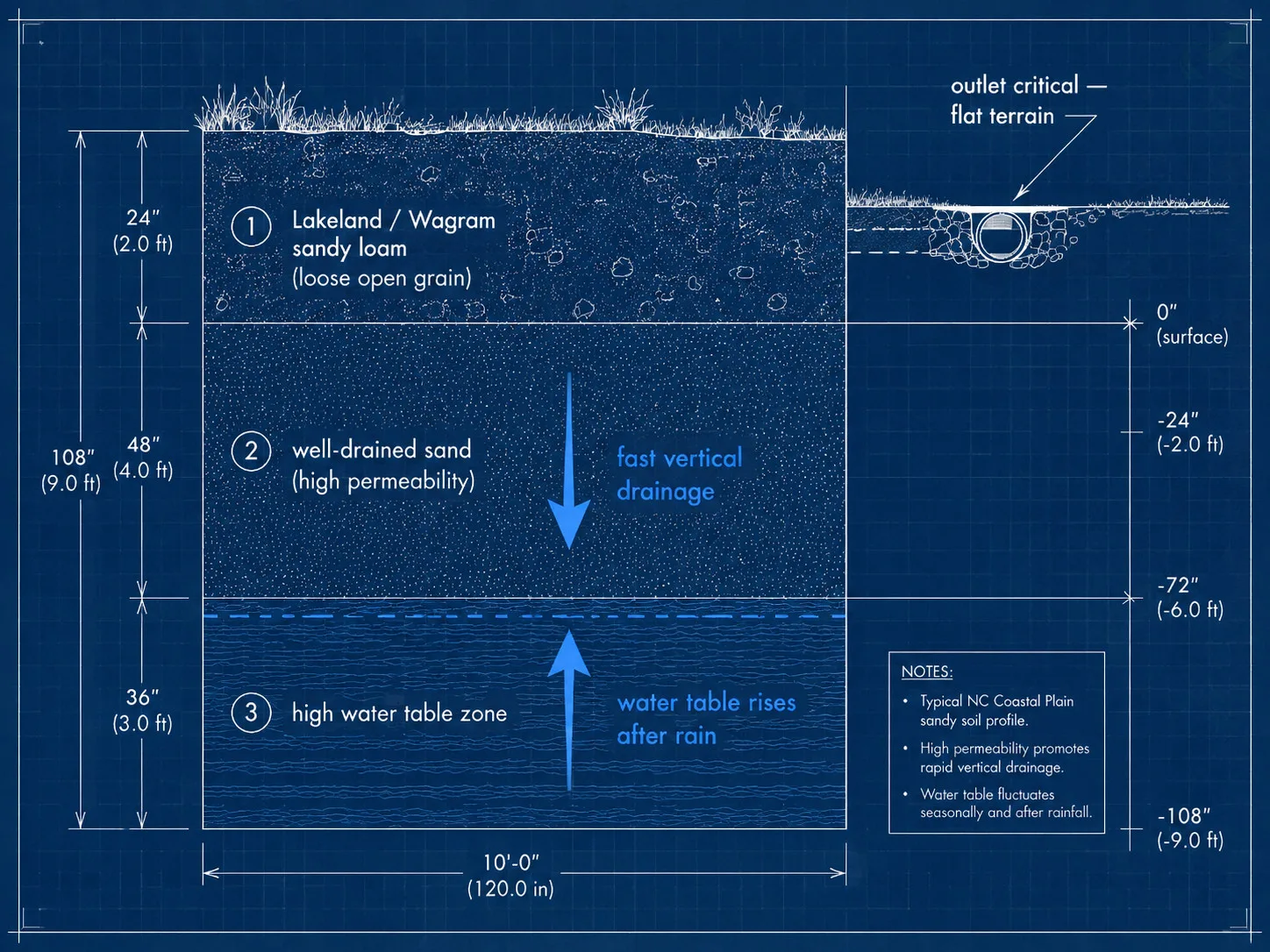
The Coastal Plain Zone: Sandy Soils and Higher Permeability
The NC Coastal Plain — east of roughly I-95, including Wilmington, Fayetteville, and the Outer Banks counties — has primarily sandy soils with much higher hydraulic conductivity, which means standard French drain methods work closer to spec here.
The dominant soil series in coastal NC includes the Lakeland and Wagram series — deep, well-drained sandy soils with little to no clay content. Water moves through them quickly. A standard 6-inch perforated pipe in #67 stone, installed at 12-18 inches, behaves predictably.
The complication is terrain and water table. The Coastal Plain is flat. Without adequate fall to an outlet, a French drain has nowhere to drain to. And in low areas near rivers and sounds, the water table sits close to the surface — especially after extended rain. High-water-table conditions reverse the economics of drainage: the soil drains fast, but the water table rises to meet you.
Coastal Plain drainage design focuses on outlet location and water-table seasonality rather than the lateral-flow interception problem that dominates Piedmont work.
Full Coastal Plain drainage design detail is at NC Coastal Plain sandy soils and drainage.
The WNC Mountain Zone: Shallow Soil Over Rock
Western NC — roughly west of the I-77/I-40 corridor — has shallow soil over granitic and metamorphic bedrock, where surface runoff dominates because there is not enough soil depth for percolation or lateral flow systems to work.
The dominant soil series in WNC mountain counties include the Ashe and Edneyville series — thin, rocky soils that sit 6-24 inches above fractured bedrock. When rain falls faster than the surface layer can absorb it, water runs. There is no B-horizon to intercept, no deep clay structure to route around. The soil is just shallow.
This is why the Hurricane Helene debris flows in October 2024 were so destructive. Rain fell onto saturated shallow soil with no percolation capacity. Water and saturated soil moved together downslope. No French drain at 18 inches would have changed that — there was nowhere to put it.
For drainage work in WNC mountain terrain, the design question is not “where does the pipe go” but “where does the surface water go.” Swales, diversion berms, and surface grading routes are the primary tools. Pipe systems require enough soil depth to matter, and WNC often does not have it.
Dave, who rebuilt his Bat Cave driveway after Helene — the methodology question for his site is surface routing before anything else. See the full WNC approach at western NC mountain soils and shallow rock.
How Soil Zone Determines Your Drainage Methodology
Same project, different soil zones: a Piedmont yard with standing water needs lateral flow interception; a Coastal Plain yard may need a simple outlet extension; a WNC mountain property may need surface grading and diversion swales rather than any French drain.
The methodology differences are not preferences. They are structural requirements of the soil.
| Zone | Primary Drainage Mechanism | Key Design Difference |
|---|---|---|
| Piedmont | Lateral flow interception — collect sideways-moving water before it reaches the problem area | Pipe placement follows the water’s lateral path; outlet must daylight below grade |
| Coastal Plain | Gravity discharge to outlet — soil drains well; the design challenge is outlet location and fall | Outlet availability and water table depth drive the design more than soil permeability |
| WNC Mountains | Surface routing via swale and diversion — soil too shallow for subsurface systems | Grade the surface; pipe systems are secondary or not viable |
Foundation drainage in NC soil zones walks through how these differences affect foundation waterproofing decisions specifically, where the stakes of a zone mismatch are highest.
NC clay methodology for French drains covers the Piedmont-specific installation requirements that differ from the national standard.
How to Find Your Zone — and What to Do Next
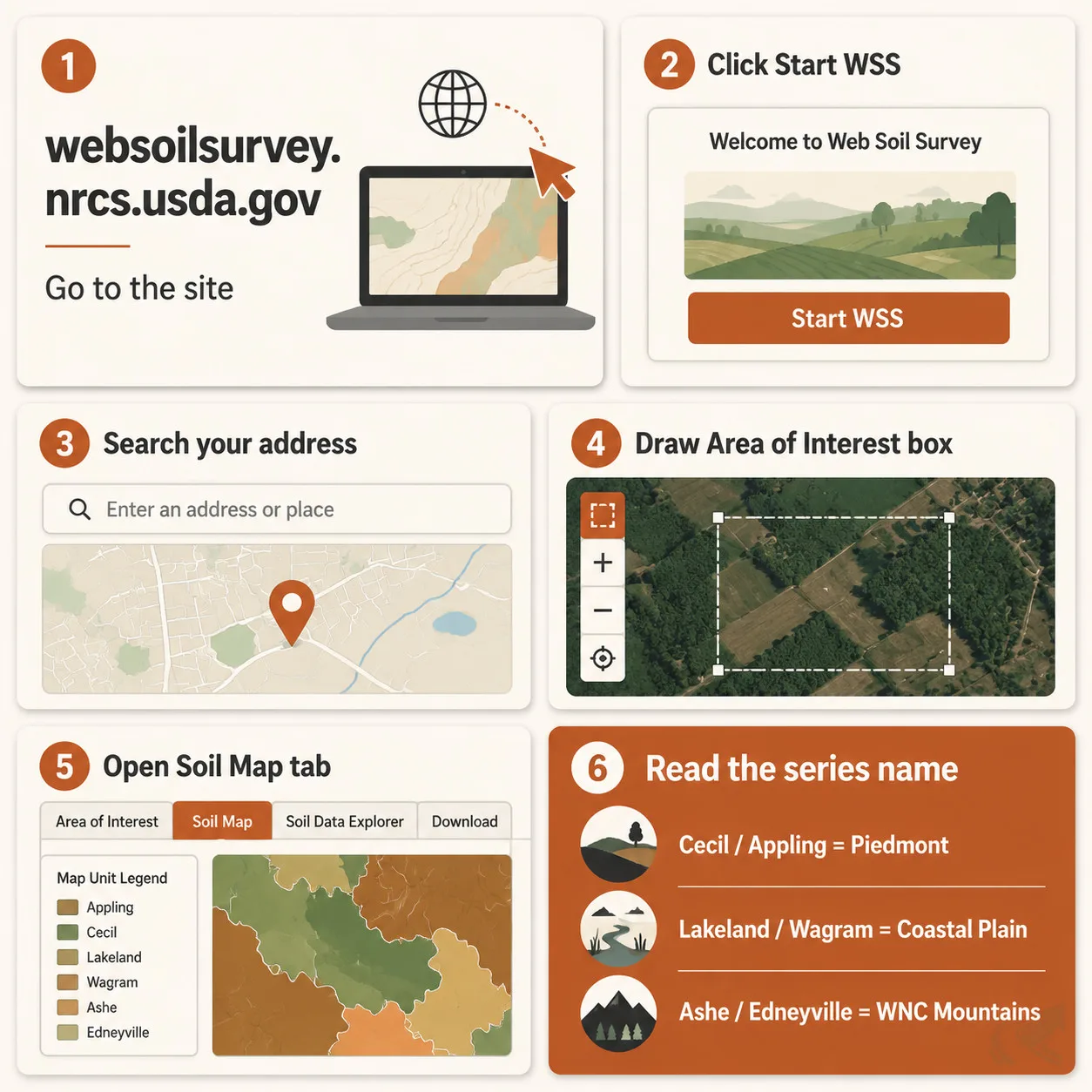
Use the USDA Natural Resources Conservation Service (NRCS) Web Soil Survey at websoilsurvey.nrcs.usda.gov to look up your property’s exact soil series — it is free and takes about three minutes.
How to use it:
- Go to websoilsurvey.nrcs.usda.gov
- Click “Start WSS” to open the map interface
- Search your address in the search bar
- Use the “Area of Interest” tool to draw a box around your property
- Click the “Soil Map” tab — it displays the dominant soil series for your parcel
- Read the series name (Cecil, Lakeland, Ashe, etc.) and match to the zones above
The series name tells you which zone you are in and what drainage behavior to expect. Cecil or Appling means Piedmont clay. Lakeland or Wagram means Coastal Plain sand. Ashe or Edneyville means WNC shallow mountain soil.
Once you know your zone, find a grading operator in North Carolina who works specifically in that soil type.